
The Calanques


Presentation
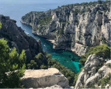
Known the world over for its imposing landscapes of limestone cliffs plunging into the sea and the Cosquer cave, the Calanques site is also home to exceptional biodiversity and cultural heritage.
The Calanques (rocky coves) along the coast between Marseille and Cassis are of exceptional beauty by their striking relief, their scale and their white rocks.
For more than twenty kilometres, the limestone cuts into the coastline, giving Marseille a splendid natural monument. Nibbled away by erosion and hacked by the waves, the rock starts to rise from the sea bed and culminates at heights of almost 400 metres above sea level.
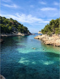
An absolute must for rock climbers, the area is also a hikers paradise. Hiking paths snake between the rocks, offering infinite possibilities for hikes, leisurely strolls and bathing. Starting from La Madrague, you can follow the coast by crossing the "end of Marseille" - Les Goudes, Callelongue and Cortiou - then continuing via Sormiou to Morgiou, Sugiton, En Vau, Port-Pin and lastly Cassis.
You can make the same trip by sea. In summer, a launch leaves the Old Port, passes by the islands in Marseille Bay (Riou, Jarre and Maïre) and goes into each of the calanques as far as Cassis, the last stage of an unforgettable trip. You can also make the same trip from Cassis.
For more than twenty kilometres, the limestone cuts into the coastline, giving Marseille a splendid natural monument. Nibbled away by erosion and hacked by the waves, the rock starts to rise from the sea bed and culminates at heights of almost 400 metres above sea level.
An absolute must for rock climbers, the area is also a hikers paradise. Hiking paths snake between the rocks, offering infinite possibilities for hikes, leisurely strolls and bathing. Starting from La Madrague, you can follow the coast by crossing the "end of Marseille" - Les Goudes, Callelongue and Cortiou - then continuing via Sormiou to Morgiou, Sugiton, En Vau, Port-Pin and lastly Cassis.
You can make the same trip by sea. In summer, a launch leaves the Old Port, passes by the islands in Marseille Bay (Riou, Jarre and Maïre) and goes into each of the calanques as far as Cassis, the last stage of an unforgettable trip. You can also make the same trip from Cassis.
Opening period (s)All year round daily.
Practical information
- Visits :
- you can visit it
Destination
Parc national des Calanques
13008
Marseille
GPS coordinates
Latitude : 43.2123
Longitude : 5.42451
We also suggest...


