
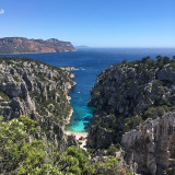
Calanque d'En Vau


Presentation
The most spectacular with its white, steep and jagged cliffs. It is the privileged place of the lovers of the climbing, amateurs or confirmed, who find here the unique sensation to be able to climb on walls between sky and sea.
The name En-Vau means "in the valley".
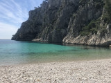
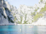
It's also a favorite with bathers, thanks to its crystal-clear water.
For many years now, as soon as the fine weather arrives, this exceptional site has been a victim of its own success, with peaks of over-frequentation by bathers and kayakers.
It is crossed by the GR98-51 long-distance hiking trail: there are two possible departure points, the Gardiole (parking lot on the Route de la Gineste between Marseille and Cassis), and from the Cassis peninsula.
This area is home to numerous climbing sites. Arriving at the bottom of the valley, there are rocky masses on the left known as "le pouce", "la grande aiguille" or "la sirène". Then you come to "la petite aiguille". Looking towards the sea, you can see the vertiginous "doigt de Dieu". The Comité Départemental de la Fédération Française de la Montagne et de l'Escalade has published a reference book entitled "Escalade les Calanques", which all regular climbers and visitors to the area should have in their backpacks for safe climbing.
Practical information
- Visits :
- you can visit it
Destination
Calanque d'En Vau
13009
Marseille
GPS coordinates
Latitude : 43.202267
Longitude : 5.498185
We also suggest...


