
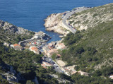
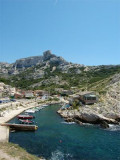
Calanque de Callelongue


Presentation
In Marseille, when we go to Callelongue, we say that we go to the end of the world.
So take a bus, the n°20, a bike, a scooter or a car and go along the sea towards the southeast. Little by little, you will have the impression of leaving the city to enter another dimension. The road, enchanting and winding, between white rocks and blue sea, will lead you to Callelongue or "Calo Longo" meaning in Provencal small narrow and long creek.
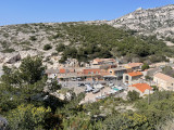
This little corner of paradise marks the end of the city and is worth the detour in itself. Cabanons with evocative names, Mediterranean gardens carefully maintained by the inhabitants and barquettes moored in the shelter of the Mistral.
As an open door to the Massif des Calanques, you can discover the calanques of Marseilleveyre, Morgiou or Sormiou, via marked hiking trails.
And if you don't have enough time, you can simply climb a few rocks to admire the view or take a dip before heading back to Marseille the city.
The roads of Morgiou, Sormiou and Callelongue are closed:
- In May and October: every weekend and during school holidays.
- From June to September: every day.
Pedestrian access on these roads is still allowed under certain conditions.
Opening period (s)All year round.
Practical information
- Visits :
- you can visit it
- Parking :
- Car park
- Free car park
Destination
Calanque de Callelongue
13008
Marseille
GPS coordinates
Latitude : 43.212229
Longitude : 5.353539
We also suggest...


