
The Hauture
Historic site and monument

Presentation
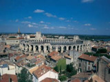
The Hauture district is the highest part of the town (25 meters above sea level), the only rocky eminence in the surrounding alluvial plain.
It was a major factor in the urbanization of the Roman colony, of which the present-day district retains monumental traces, notably the amphitheatre, theater and rampart.
In addition, the remains of the first episcopal group are currently being uncovered in the southeast corner of the district.
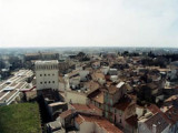
Later, its population of small farmers, shepherds and craftsmen left their mark on its picturesque appearance, with small, simple houses and narrow, winding streets, some still paved.
Its heritage interest, rich past and pleasant atmosphere make it a very popular area for visitors. Like the rest of the town center, it is part of the protected area.
As early as the 6th century BC, the Hauture rock was occupied by natives trading with the Phocaean city of Massalia. Later, as in the whole of the fledgling city, Celto-Ligurian and then Italian settlement predominated.
But it was with the founding of the Roman colony in 46 BC that the district saw its first monumental urbanization. The theater (and, a century later, the amphitheater) were built here, and a city wall was erected, the eastern section of which is still visible today. The Porte d'Auguste (Augustus Gate), opening onto the rampart, was the arrival point for the Aurelian Way from Italy, making the Hauture an essential point of passage.
This district was also the site of the early Christian cathedral, before it was moved to the forum.
In the Middle Ages, religious power ceded the area to the neighboring Cité district, and Hauture was reduced to a parish around the Notre-Dame-de-la-Major church. Until the French Revolution, this parish was the largest and most populous in the city. The amphitheater, built and reinforced with towers, asserted its defensive vocation.
During the Renaissance, political power and urban planning refocused the town to the west, leaving Hauture with a rural, artisanal character. With the exception of the development of the Abbey of Saint-Césaire, and its function as a "water tower" in the 20th century (see the old reservoirs and tower), the Hauture district essentially retained its character as a small, old, individual dwelling.
In addition, the remains of the first episcopal group are currently being uncovered in the southeast corner of the district.
Later, its population of small farmers, shepherds and craftsmen left their mark on its picturesque appearance, with small, simple houses and narrow, winding streets, some still paved.
Its heritage interest, rich past and pleasant atmosphere make it a very popular area for visitors. Like the rest of the town center, it is part of the protected area.
As early as the 6th century BC, the Hauture rock was occupied by natives trading with the Phocaean city of Massalia. Later, as in the whole of the fledgling city, Celto-Ligurian and then Italian settlement predominated.
But it was with the founding of the Roman colony in 46 BC that the district saw its first monumental urbanization. The theater (and, a century later, the amphitheater) were built here, and a city wall was erected, the eastern section of which is still visible today. The Porte d'Auguste (Augustus Gate), opening onto the rampart, was the arrival point for the Aurelian Way from Italy, making the Hauture an essential point of passage.
This district was also the site of the early Christian cathedral, before it was moved to the forum.
In the Middle Ages, religious power ceded the area to the neighboring Cité district, and Hauture was reduced to a parish around the Notre-Dame-de-la-Major church. Until the French Revolution, this parish was the largest and most populous in the city. The amphitheater, built and reinforced with towers, asserted its defensive vocation.
During the Renaissance, political power and urban planning refocused the town to the west, leaving Hauture with a rural, artisanal character. With the exception of the development of the Abbey of Saint-Césaire, and its function as a "water tower" in the 20th century (see the old reservoirs and tower), the Hauture district essentially retained its character as a small, old, individual dwelling.
General information
- Park :
- Camargue Regional Nature Park
Services, Tours, Activities and entertainment
- Historical patrimony :
- Historic patrimony
- Historic district
Contact
The Hauture
13200
Arles
Phone : +33 4 90 18 41 20

Destination
L'Hauture
13200
Arles
GPS coordinates
Latitude : 43.675865
Longitude : 4.631853