
Martigues’ Vineyard Trails - Panoramic trail
Pedestrian sports, Hiking itinerary Interdepartmental InterdepartmentalItinéraire
 Departure/Arrival
 Point of interest
Circuit n° 1
A section of the vineyard trail is closed by prefectural decree until June 15, 2026, following the fire of July 17, 2025. The closure is due to the risk of falling weakened or charred trees, the presence of eroded or unstable soil, and areas of severe erosion that could exacerbate landslides.
Download the decree for more details.
Download the decree for more details.
Presentation
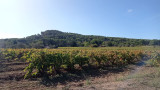
Between the Mediterranean and Etang de Berre, on the western edge of the Nerthe massif, lies the terroir of Venice Provençale.
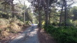
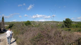
In the heart of the vineyards and trails on the land of the Saint-Julien-les-Martigues wine cellar, take a breath of fresh air! Located in the countryside, you will love enjoying the wild landscapes, wandering in the fields and being amazed at the farms that you come across on your way.
1 – From Saint Julien’s winery, take the D 5 road on your left (road to Sausset).
2 – After 0.3 miles, at the traffic light, turn right in the Chemin des Jardins. Stay on the right. Go to the Chemin des Jourdans. At the street lamp, turn left between the vineyards and up to the houses. Turn right, follow the trail overhanging the vineyards up to an ancient farmhouse. Round the construction by walking on the left (threshing yard).
3 – Go down the trail on the right. Reach the Chemin des Audiberts.
4 – Walk straight to the D 5 road (0.3 miles); cross the road (carefully!) slightly to the left. Go to the Valtrède dale and GR® 2013*.
5 – Turn right. Follow the road for 0.4 miles.
6 – A trail is going right (gate) and leads to a slope then to a watchtower on the left, an ancient mill. Go back to the path and keep walking to the right between vineyards and olive trees for 0.7 miles.
7 – Leave the GR® 2013. Follow on the right the Chemin de Beaumenière, the path crosses a pine forest, a hamlet and threads into the
vineyards.
8 – Turn right and follow the D 5 until you’re back to the winery (0.6 miles).
Opening period (s)All year round daily.
Subject to favorable weather.
Subject to favorable weather.
Practical information
- Route :
- Signposted route
- Distance (km) : 11
- Daily duration (minutes) : 150
- Route : BOUCLE
- Route : 187
- Parking :
- Free car park
- Levels of sporting experience :
- Level bue - Medium
- Natures field :
- Clay
Features/Theme
- Environments :
- In the country
- Village 2 km away
- Presence of herds and guard dogs
Download
Contact
233 Route de Sausset
Cave Vinicole de Saint-Julien
13500
Martigues
Photos


We also suggest...

