
GR2013 - A07 - From Gare de Croix Sainte to Port de Bouc
Pedestrian sports, Hiking itinerary Interdepartmental Interdepartmental Departure/Arrival
 Point of interest
Presentation
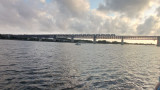
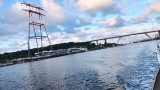
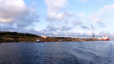
Section A07 of the GR2013. From Gare de Croix Sainte (Martigues) to Port de Bouc. A 3.7km route to discover a natural and industrial landscape.
The border between the two districts, Martigues and Port de Bouc is marked by the Rivière de la Gafette which is the official border between the two cities. Note: the expansive industrial wasteland of the former Azur Chimie factory, a bromine treatment site, which closed in 2010.
Opening period (s)All year round daily.
Practical information
- Route :
- Signposted route
- Distance (km) : 3.7
- Daily duration (minutes) : 90
- Route : Aller / Itinerance
- Route : 34
- Parking :
- Free car park
- Levels of sporting experience :
- Level green –very easy
- Natures field :
- Hard coating (tar, cement, flooring)
- Suitable for city strollers
Features/Theme
- Environments :
- Town location
Download
Pics


We also suggest...
