
Montaiguet, Hills of Gardanne
Mountain

Presentation
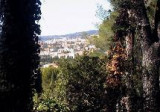
The Massif du Montaiguet forms a small semi-circular massif, standing shoulder-to-shoulder with Aix-en-Provence to the northwest and the town of Gardanne to the southeast. It is delimited to the North and East by the A8 highway, to the South by the RD6 road and to the West by the RN8 road.
This hill-shaped massif, oriented northeast / southwest, is carved with numerous northwesterly facing valleys, situated between Vallée de l’Arc and the Gardanne catchment area. It comprises chalky plateaux bordered by cliffs, plus several dips where crops grow. It rises to an altitude of 346 metres and its lowest point is situated to the North, at just 145 metres.
Part of Provence's coastal climate zone, the Massif du Montaiguet benefits from a typical Mediterranean climate, with prevailing Mistral winds due to its orientation. …
Montaiguet forms part of the small, natural region of Bassin de l’Arc. It is fairly thinly forested (50 %), with mainly dense and irregular populations of Aleppo pines mixed with evergreen oaks and durmast oaks on the North-facing slopes and in the valleys. The areas previously devastated by forest fires (in particular those of 1979 and 2005) are mainly covered with garrigue and re-planted trees.
Bordered by several urban centres (Aix-en-Provence, Gardanne, Luynes and Bouc-Bel-Air), the fringe areas and even central areas of the Massif du Montaiguet are relatively densely populated further to the extension of peri-urban business parks and ever-increasing social demand on woodland. However, the multiplication of individual houses in the massif appears to have stabilized in the last twenty years or so.
This massif is coveted for both its scenery and sporting opportunities, in particular by the inhabitants of Aix-en-Provence, but it also suffers from the effects of human activity. Montaiguet is of ornithological interest, with the presence of three remarkable species: the eagle owl, the common scops owl and the little owl.
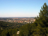
The Collines de Gardanne (Gardanne Hills) form a small massif (5,800 acres) situated in the eastern half of the Bouches-du-Rhône region, to the southeast of Aix-en-Provence, between the Arbois, Sainte-Victoire, Regagnas and Etoile chains.
It comprises a set of hills of low average altitude and with gentle slopes. …
Average temperatures are fairly warm, but vary pretty widely throughout the year, with frequent frosts in winter and intense heat in summer. Rainfall ranges from around 600-700 mm/year. Although it is not exactly aligned with the Rhône valley, the Collines de Gardanne massif is frequently swept by the Mistral wind.
Forming part of the small natural region of Bassin de l’Arc, the massif is densely forested (74%) despite its high urban development, with 80 % Aleppo pines, plus around 20% evergreen oaks and rare garrigue.
Part of Provence's coastal climate zone, the Massif du Montaiguet benefits from a typical Mediterranean climate, with prevailing Mistral winds due to its orientation. …
Montaiguet forms part of the small, natural region of Bassin de l’Arc. It is fairly thinly forested (50 %), with mainly dense and irregular populations of Aleppo pines mixed with evergreen oaks and durmast oaks on the North-facing slopes and in the valleys. The areas previously devastated by forest fires (in particular those of 1979 and 2005) are mainly covered with garrigue and re-planted trees.
Bordered by several urban centres (Aix-en-Provence, Gardanne, Luynes and Bouc-Bel-Air), the fringe areas and even central areas of the Massif du Montaiguet are relatively densely populated further to the extension of peri-urban business parks and ever-increasing social demand on woodland. However, the multiplication of individual houses in the massif appears to have stabilized in the last twenty years or so.
This massif is coveted for both its scenery and sporting opportunities, in particular by the inhabitants of Aix-en-Provence, but it also suffers from the effects of human activity. Montaiguet is of ornithological interest, with the presence of three remarkable species: the eagle owl, the common scops owl and the little owl.
The Collines de Gardanne (Gardanne Hills) form a small massif (5,800 acres) situated in the eastern half of the Bouches-du-Rhône region, to the southeast of Aix-en-Provence, between the Arbois, Sainte-Victoire, Regagnas and Etoile chains.
It comprises a set of hills of low average altitude and with gentle slopes. …
Average temperatures are fairly warm, but vary pretty widely throughout the year, with frequent frosts in winter and intense heat in summer. Rainfall ranges from around 600-700 mm/year. Although it is not exactly aligned with the Rhône valley, the Collines de Gardanne massif is frequently swept by the Mistral wind.
Forming part of the small natural region of Bassin de l’Arc, the massif is densely forested (74%) despite its high urban development, with 80 % Aleppo pines, plus around 20% evergreen oaks and rare garrigue.
Practical information
- Visits :
- you can visit it
Contact
Montaiguet, Hills of Gardanne
13090
Aix-en-Provence
Destination
Montaiguet, Collines de Gardanne
13090
Aix-en-Provence
GPS coordinates
Latitude : 43.479332
Longitude : 5.487499