
Le Mourre Nègre
Mountain

Presentation
The highest point of the Grand Luberon is called "le Mourre Nègre".
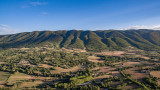
From the village, two hiking trails guide visitors to this peak which culminates at 1125 meters.
IGN Top 25 map 3242
Duration : 5 hours
Distance : 9 km
Difference in altitude : 600 meters
From the village, two hiking trails guide visitors to this peak which culminates at 1125 meters.
IGN Top 25 map 3242
Duration : 5 hours
Distance : 9 km
Difference in altitude : 600 meters
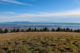
Its ascent of the Mourre Nègre crosses several stages of vegetation until the summit lawns of the crests and a panorama which extends until the Mediterranean Sea.
Opening period (s)All year round.
Practical information
- Visits :
- you can visit it
- Services :
- Pets welcome
Contact
Le Mourre Nègre
84400
Auribeau
Destination
Le Mourre Nègre
84400
Auribeau
GPS coordinates
Latitude : 43.814996
Longitude : 5.467585