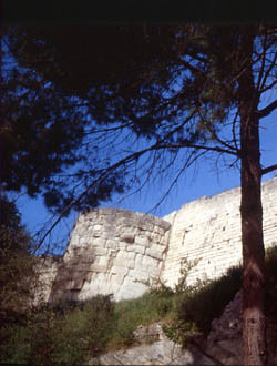
Gate of Augustus
Historic site and monumentPresentation
Sometimes called Porte de la Redoute
Date: Late 1st century BC
Period: Antiquity
Type : Fortified military architecture
Status: Property of the City of Arles Classified as a Historic Monument (1886), Unesco World Heritage Site (1981)
Date: Late 1st century BC
Period: Antiquity
Type : Fortified military architecture
Status: Property of the City of Arles Classified as a Historic Monument (1886), Unesco World Heritage Site (1981)
The Porte d'Auguste, also known as the Porte de la Redoute (after the fortress built there in the Middle Ages), was the main entrance to the Roman city.
Situated at the highest point of the city, to the east, it was home to a branch of the Aurelian road from Rome.
It is the best-preserved part of the Augustan rampart, built shortly after the birth of the Roman colony.
The gate's current dominant position doesn't correspond to the original height difference, but to the digging of Boulevard Emile-Combes at the end of the 18th century.
Close to the gate's north tower, the aqueduct brought water from the Alpilles.
Limestone deposits can still be seen on the fracture caused by the digging of the boulevard.
The building was extensively remodeled in Late Antiquity and during the Middle Ages.
The gate, framed by two rectangular massifs, occupies a vast half-moon-shaped area of around one hundred meters in the eastern part of the rampart.
At each end of the gate, a semicircular tower provided a link with the curtain wall (part of the enclosure between two bastions).
The gate itself was 35 metres wide. In contrast to the curtain wall, it was built of large stone blocks, assembled with clean joints.
The two surrounding semicircular towers, also made of large blocks of stone, feature relatively simple moulding at their bases, which is very damaged at the top.
The space between the two towers allows the restoration of two 15-metre-wide passageways, probably not wide enough for additional pedestrian traffic, as is the case with the wider Porte d'Auguste in Nîmes.
The gate was walled up in the Middle Ages, and today only a small postern can be seen.
General information
- Style :
- Ancient
- Park :
- Camargue Regional Nature Park
Services, Tours, Activities and entertainment
- Historical patrimony :
- Historic patrimony
- Door
Contact
Gate of Augustus
Boulevard Emile Combes
13200
Arles
Phone : +33 4 90 18 41 20

Destination
Porte d'Auguste
Boulevard Emile Combes
13200
Arles
GPS coordinates
Latitude : 43.67815
Longitude : 4.633657


