Arles and Etang de Vaccarès lake
Interdepartmental, Interdepartmental, Interdepartmental Cycling sports Cycle tourism route Tourist itinerary Departure/Arrival
 Point of interest
Presentation
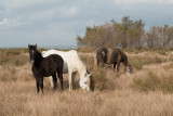
The Camargue vibrates with all its ponds. This wide circuit proposes an exploration to the shores of the largest and most famous of between them: Vaccarès.
Starting from Arles, capital of the history and culture of the Camargue, the itinerary descends southward, through market gardens and rice fields. It then leads to the banks of the Vaccarès pond to discover a succession of infinite panoramas, where the water merges with the sky.
From the Arles Tourist Office, turn left onto Boulevard des Lices, then right onto Rue Gambetta in the direction of Trinquetaille and Saintes-Maries-de-la-Mer. Cross the Rhone river and continue in the direction of Saintes- Maries and Salin-de-Giraud.
At the traffic circle (be careful), take the direction of Gimeaux, route communale 108. Until Gimeaux, follow the green signs "Chemin des taureaux et de la vigne".
In the hamlet, continue until the second sign on the left, which indicates the school of Gimeaux. Take this direction, pass in front of the school which is left on the left and continue.
After one kilometer, join the D570 (be careful, this road is very busy!), take on the right the D570 on a hundred meters. Then turn left on the communal road C125, direction "La Dougue Bouchaud".
Continue for about a kilometer at the second intersection, take on the right the "Petit chemin de Sainte Cécile". Progress along roads lined with trees. Numerous greenhouses are evidence of important market gardening.
At the first crossroads, at the Mas de Pédassas, continue straight ahead in the direction of the Vaccarès pond.
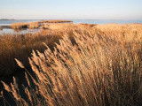
Then cross reed beds and a landscape essentially composed of rice fields. After crossing the Mas Sainte Cécile, continue in the direction of the Vaccarès pond. It is an extremely clear landscape which makes you perceive the immensity of the Camargue territory.
When you reach the D37, turn right for 500 meters to stop at the observation point set up by the Parc Naturel Régional de Camargue: a platform and explanatory panels present the flooded marshes and the Vaccarès pond in the distance. Go back on your steps and continue on the D37 to Villeneuve.
In this hamlet, turn left onto the D36b towards Gageron and Arles.
In Gageron, turn left on the communal road 130 "De Bouchaud à Gageron", leave the church and the school on your left to leave Gageron and go back into the Camargue countryside. After 4 km, join the communal road C125, then the D570 where the circuit began. Join Arles by Gimeaux as you did on the way out.
From the Arles Tourist Office, turn left onto Boulevard des Lices, then right onto Rue Gambetta in the direction of Trinquetaille and Saintes-Maries-de-la-Mer. Cross the Rhone river and continue in the direction of Saintes- Maries and Salin-de-Giraud.
At the traffic circle (be careful), take the direction of Gimeaux, route communale 108. Until Gimeaux, follow the green signs "Chemin des taureaux et de la vigne".
In the hamlet, continue until the second sign on the left, which indicates the school of Gimeaux. Take this direction, pass in front of the school which is left on the left and continue.
After one kilometer, join the D570 (be careful, this road is very busy!), take on the right the D570 on a hundred meters. Then turn left on the communal road C125, direction "La Dougue Bouchaud".
Continue for about a kilometer at the second intersection, take on the right the "Petit chemin de Sainte Cécile". Progress along roads lined with trees. Numerous greenhouses are evidence of important market gardening.
At the first crossroads, at the Mas de Pédassas, continue straight ahead in the direction of the Vaccarès pond.
Then cross reed beds and a landscape essentially composed of rice fields. After crossing the Mas Sainte Cécile, continue in the direction of the Vaccarès pond. It is an extremely clear landscape which makes you perceive the immensity of the Camargue territory.
When you reach the D37, turn right for 500 meters to stop at the observation point set up by the Parc Naturel Régional de Camargue: a platform and explanatory panels present the flooded marshes and the Vaccarès pond in the distance. Go back on your steps and continue on the D37 to Villeneuve.
In this hamlet, turn left onto the D36b towards Gageron and Arles.
In Gageron, turn left on the communal road 130 "De Bouchaud à Gageron", leave the church and the school on your left to leave Gageron and go back into the Camargue countryside. After 4 km, join the communal road C125, then the D570 where the circuit began. Join Arles by Gimeaux as you did on the way out.
Opening period (s)All year round daily.
Practical information
- Route :
- Distance (km) : 46
- Daily duration (minutes) : 180
- Route : BOUCLE
- Levels of sporting experience :
- Level bue - Medium
- Park :
- Camargue Regional Nature Park
Contact
Départ Office de tourisme
13200
Arles