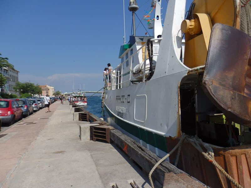
Water trail in and around the city centre
Pedestrian sports, Course, Hiking itinerary Interdepartmental InterdepartmentalItinéraire
 Departure/Arrival
 Point of interest
Point 1 - Departure from the Town Hall
The start of this loop will be in front of the entrance to the town hall. In the roundabout of this one, you will notice an ornamental fountain.
You will walk along avenue Sammut to the theater in front of which you will turn into rue P.Coubertin, then right into Chemin de Paradis.
In front of the CPAM building: On this site was erected in 1900 a building for the sum of 3639.03 fr and having 19m long and 7m wide and 4.70m high, open on the sides and covered by a roof. Inside there was a washhouse 13m by 2.5m with a large 9m bin and 2 bins one 1.5m the other 2.5m The whole was covered by a roof, it was used a good part of the XX Century.
Go around the CPAM on your left and go up Bd Kennedy slightly
On your right below the cemetery, you will see a series of arches creating a small aqueduct. On top of it circulated the Canal de Martigues. This canal was built between 1869 and 1886 and linked the Merle basin in Salon de Provence to the Serre basin in Martigues, it was 40 km long.
Point 2 - Head to the Théâtre de Verdure
Retrace your steps and you head by the quai des girondins and the quai Tesse towards the green theater.
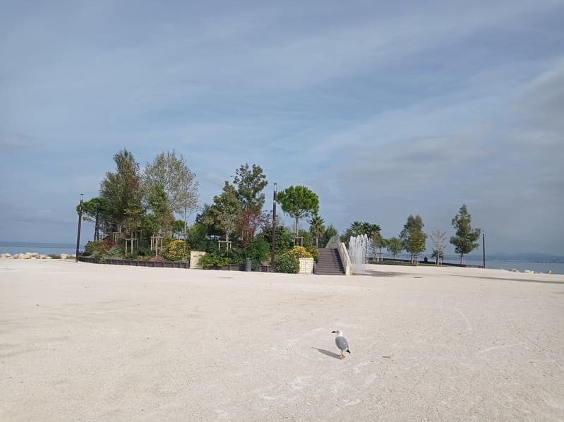
On its southern part you will notice a series of water jets which were installed during the construction of the theater in 2018, then cross the garden of Ferrières.
At the beginning of it there is a series of 12 water jets which replace a pretty fountain until then in this place.
At the first aid station (the fountain with water jets dates from 2021), turn left on Bd du 14 Juillet for 50m
At the intersection with rue Salengro (on your left), here was the Puits Marguière, this well, on the edge of the old ramparts just before the Porte Marguière, only appeared from 1542, it was one of the two main wells of Ferrières. He disappears with the ramparts.
Take the Bd Fleming (which is the old road to St Miter les Remparts), until the junction with the Allée Lavoisier.
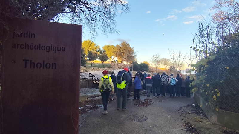
Point 3 - The Tholon site
Walk along the Allée Lavoisier, cross the parking lot of the swimming pool and join the edge of the pond.
You follow the blue markings through the Jardin de la Rode, you arrive at the Tholon site.
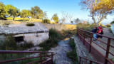
First of all you will see a wash house capturing on the one hand the source of Tholon, on the other hand the water of the ARC which ends a few meters further (90m) at the foot of a small building.
This place has been exploited since Gallo-Roman times (site of the city of Maritima Avaticorum) and the name of Tholon coming from Tholonium (customs post) which would prove that this place was a toll for the water supply of ships .
The source of Tholon is the main source of fresh water near the village of Férrières, located at 1400m. In 1457 Martigues was made up of 3 fortified and independent districts. Charles du Maine, Lord of Ferrières, had a pipeline built between the Source and the Quai des Girondins. The work was completed in 1562 but following numerous landslides the fountain ceased to flow in 1470.
In 1478, the consuls of the 3 districts decided to rebuild an underground aqueduct between Tholon and a fountain on Place J. Jaures. The works lasted 2 years including large stone structures. A wind pump was installed on the Arc source to increase the flow of the Tholon source. Even if we have no route of this pipeline, we know certain points of its passage following the meetings carried out during the construction work of the various dwellings between Tholon and Ferrières.
Leaving Tholon, return on the way to go to Fleming avenue which you cross at the pedestrian crossing of the roundabout. Go down the avenue until the Jardin du Prieuré, continue on the avenue Fleming until N ° 38. You have followed the route of the aqueduct which should pass through the middle of the houses on your left.
You follow the blue markings through the Jardin de la Rode, you arrive at the Tholon site.
First of all you will see a wash house capturing on the one hand the source of Tholon, on the other hand the water of the ARC which ends a few meters further (90m) at the foot of a small building.
This place has been exploited since Gallo-Roman times (site of the city of Maritima Avaticorum) and the name of Tholon coming from Tholonium (customs post) which would prove that this place was a toll for the water supply of ships .
The source of Tholon is the main source of fresh water near the village of Férrières, located at 1400m. In 1457 Martigues was made up of 3 fortified and independent districts. Charles du Maine, Lord of Ferrières, had a pipeline built between the Source and the Quai des Girondins. The work was completed in 1562 but following numerous landslides the fountain ceased to flow in 1470.
In 1478, the consuls of the 3 districts decided to rebuild an underground aqueduct between Tholon and a fountain on Place J. Jaures. The works lasted 2 years including large stone structures. A wind pump was installed on the Arc source to increase the flow of the Tholon source. Even if we have no route of this pipeline, we know certain points of its passage following the meetings carried out during the construction work of the various dwellings between Tholon and Ferrières.
Leaving Tholon, return on the way to go to Fleming avenue which you cross at the pedestrian crossing of the roundabout. Go down the avenue until the Jardin du Prieuré, continue on the avenue Fleming until N ° 38. You have followed the route of the aqueduct which should pass through the middle of the houses on your left.
Point 4 - Towards the old Serre basin
Turn right into the Allée des Promeneurs.
At the end of this you come to a square with a pretty fountain, dating from around 1964.
Take a slight right (30m) you find yourself at the old Bassin de la Greenhouse.
It was for a long time the seat of the water service (see inscription on the facade): it is currently the Archaeological Service.
During the construction of the Martigues canal (1858-1886), there was a 30m3 water storage basin in order to supply the districts of the island and Ferrières. Later a 750m3 water tower was built to increase the pressure. All the structures were destroyed in 2009.
From this point we will follow the underground pipe which brought water to the district of Ferrières, then to the Island.
For that, let's go down the Bd Joliot Curie.
At the intersection with the Bd du 14 Juillet, there was a basin. Cross the Boulevard and turn left following the remains of the old rampart.
Take the rue du Grand Four, then turn right in the rue des Serbes, you come out in the place J.Jaurès.
Facing the rue du Grand Four you have the rue de la Chaîne and at the end of this street there was the Borneau fountain (1828-1861) removed during work on the swing bridge and those on the quay. It had a basin and a pile for the laundry.
Point 5 - The blue bridge
Let us return to the place J.Jaurès (former place of the palace).
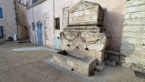
At the site of the pizzeria there was a fountain which also served as a washhouse dating from 1659, the pools were protected by a stone awning.
This fountain was supplied directly from Tholon and was dismantled in 1863 and replaced by the old fountain which was at the level of the blue bridge.
In 1863, a fountain was also installed on Place J. Jaures, a fountain with a circular base and positioned in front of the bakery.
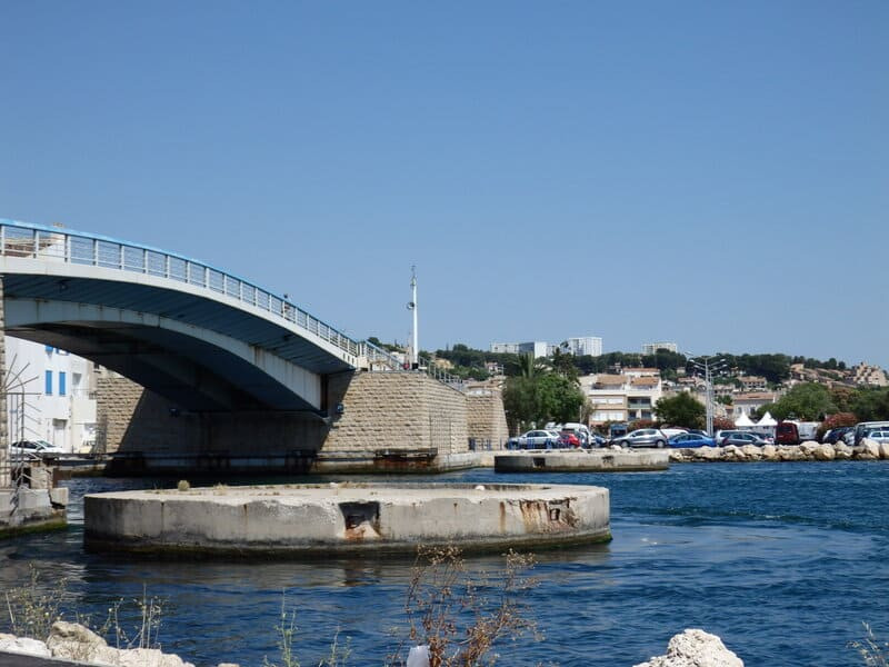
Cross the blue bridge at the end of it slightly to the right, take the rue Galinière.
At the beginning of this street there was a small square: the courtyard plan (place comtat) which included a fountain which was supplied from the pipeline by the rue de la Chaîne and the crossing of the Baussengue canal by an overturned siphon.
Continue down the street to reach Place Mirabeau.
This fountain was moved to Place Mirabeau in 1862. The fountain that you see was brought from the Jonquières district in 1961. It replaced the pump fountain in 1947, IN 1954 the city installed small pump fountain in the districts and in particular one in front of N ° 8 of the place Mirabeau.
There were 30 pumps (there is one in the entrance to the Parc des sports Julien Olive).
Join the Liberation Square via the Bird's Mirror and the Saint Sébastien Bridge. As you pass, stop in front of the facade of the Sainte Madeleine church on the far right (to the north) there was a fountain still visible in the 1920s.
The fountain in front of you was installed on this square in 1881 to celebrate the arrival of fresh water from the Durance through the Martigues canal.
Follow the Saint Sébastien canal to the footbridge (Bourvil and Fernandel statues), cross the footbridge and continue on rue E.Pelletan.
At the intersection with the rue des cordonniers you will notice a wall fountain (ornament).
At the site of the pizzeria there was a fountain which also served as a washhouse dating from 1659, the pools were protected by a stone awning.
This fountain was supplied directly from Tholon and was dismantled in 1863 and replaced by the old fountain which was at the level of the blue bridge.
In 1863, a fountain was also installed on Place J. Jaures, a fountain with a circular base and positioned in front of the bakery.
Cross the blue bridge at the end of it slightly to the right, take the rue Galinière.
At the beginning of this street there was a small square: the courtyard plan (place comtat) which included a fountain which was supplied from the pipeline by the rue de la Chaîne and the crossing of the Baussengue canal by an overturned siphon.
Continue down the street to reach Place Mirabeau.
This fountain was moved to Place Mirabeau in 1862. The fountain that you see was brought from the Jonquières district in 1961. It replaced the pump fountain in 1947, IN 1954 the city installed small pump fountain in the districts and in particular one in front of N ° 8 of the place Mirabeau.
There were 30 pumps (there is one in the entrance to the Parc des sports Julien Olive).
Join the Liberation Square via the Bird's Mirror and the Saint Sébastien Bridge. As you pass, stop in front of the facade of the Sainte Madeleine church on the far right (to the north) there was a fountain still visible in the 1920s.
The fountain in front of you was installed on this square in 1881 to celebrate the arrival of fresh water from the Durance through the Martigues canal.
Follow the Saint Sébastien canal to the footbridge (Bourvil and Fernandel statues), cross the footbridge and continue on rue E.Pelletan.
At the intersection with the rue des cordonniers you will notice a wall fountain (ornament).
Point 6 - San Crist Point
At No. 12 E. Pelletan in this house directly above the walls, there are wells.
For many centuries the scarcity of fresh water affected Martigues. Also, many houses had wells which although giving brackish water were widely used. This habit led to many diseases (in 1752 there were 42 wells). Under the Ile district there was a sheet of fresh water surrounded by salt water.
Come back to the footbridge - do not cross it - turn right, follow the platform to the Parking lot.
Turn left and cross the bridge.
Pointe Saint-Christ: this esplanade was fitted out in 2010. It includes water features and small waterfalls, all with a play of lights, all designed by Pierre LUU.
At the beginning of this esplanade, you will find the landing stage of the free shuttle which will allow you to cross the Galllifet Canal.
Turn right and walk along Bd Ziem crossing the car park.
At this level existed the Eygadier Well, continue your route through the Lapidary Garden. At the level of the football stadium, there was the garden well.
Go into the industrial zone and cross it by avenue J.Nobre, at the end turn left rue Sauvage and join the roundabout, cross it. A short distance away was the Gacharelle well.
Cross rue Vaucasson at the roundabout. Nearby you will find the well of the Gacharelle which dates from the 13th century. It was close to the Saint Genest enclosure located between the Aurelio stadium and the Richardson establishments, and it remained in place until the middle of the 20th century. Today, there are no remains.
Point 7 - Direction Sainte-Anne
After crossing the roundabout take the path crossed by a chain and follow the map.
When you get to the Route de Saint-Pierre, turn left and go down it to the traffic lights, turn right onto Bd M.Cachin.
At the traffic lights, turn right for 50m. The May 8 day nursery houses in its basement a 4000m3 cistern which was built in 1905 and was filled by an underground pipe connecting it to the greenhouse basin. The flow of this one being insufficient, this reservoir was connected to the water of the canal of Marseilles by a pipe which we will follow.
This pipe passes behind the MJC (Bd E. Herriot) to arrive at St Anne.
At this location there was the Chapelle St Anne as well as the Courradou fountain, renovated in 1608.
Continue on Av F. Mistral until you reach the level of the small garden (municipal information panel)
A reservoir was installed there between 1613 and 1615 as well as a pipe making it possible to connect the Courradou watercourse to that of Vabre between 1615 and 1616. Its purpose is to make the connection with the old fountain of the course. In 1887 a washhouse was built there, 19.45m long by 6.85m wide, which was covered in 1892.
In 1977 you could see a small fountain in this garden.
Let 's follow the aqueduct down the Av F. Mistral. Passing in front of Av P. Di Lorto, admire the Fountain at N ° 2 (inside private property), continue on Mistral and turn left into rue O. Ortis. Go all the way: you come to Place Lafayette.
Point 7 - The Course of September 4
The fountain in Place Lafayette dates from the Middle Ages (14th century), it was known under the name of Vieux Puits.
It was the main well inside the ramparts of Jonquières. It was rebuilt in 1847 later, this fountain took the name of Brandarello.
Take rue L. Gambetta to join the Cours (esplanade of September 4)
In the corner of the "Renaissance" hotel, there was a fountain since 1316 which was supplied by the Vabre aqueduct. This fountain, following a request for expansion, was dismantled in 1961 and then reassembled on Place Mirabeau in Isle. (current fountain). Place des martyrs: a fountain still existed in 1938.
Go towards the fountain of the course at the entrance to rue Lamartine.
This fountain was inaugurated on December 7, 2013.
Enter rue Lamartine. To the right, there is a fountain in Place Tenque.
This fountain dates from the late 80's but before that there were 2 other fountains. One between 1881 and 1885 with a stone support (pump fountain) and the other at the beginning of the 20th century in cast iron. The current fountain made its appearance at the end of the 80s when rue Lamartine was put into a pedestrian street.
Return to the course and reach the fountain opposite the Cascade building.
Like the other fountain in the course, it was inaugurated on December 17, 2013. It replaced a fountain installed in the 1930s.
You can reach your starting point by crossing the lift bridge, the Blue Bridge, turn left, and following the quays to reach the Hôtel de Ville.
Presentation
Martigues is a city surrounded by water that was its main wealth for many years many centuries but this water is salty. This city consists of three districts connected by many bridges, which allowed it to be called "The Provencal Venice".
Departing from the Town Hall, you will discover the water points which adorned the squares of Martigues. You can admire the remains of the past as well as current monuments.
The particularity of this hike: it allows you to reach the archaeological site of Tholon and discover its washhouse.
From bridge to bridge, you will then reach the city center of Martigues to admire the water jets, canals and fountains arranged in the main squares.
The particularity of this hike: it allows you to reach the archaeological site of Tholon and discover its washhouse.
From bridge to bridge, you will then reach the city center of Martigues to admire the water jets, canals and fountains arranged in the main squares.
Opening period (s)All year round daily.
Subject to favorable weather.
Subject to favorable weather.
Practical information
- Route :
- Distance (km) : 14
- Daily duration (minutes) : 360
- Route : BOUCLE
- Parking :
- Free car park
- Levels of sporting experience :
- Level bue - Medium
- Natures field :
- Suitable for all terrain strollers
- Hard coating (tar, cement, flooring)
Features/Theme
- Environments :
- In centre of town
- Town location
Download
Contact
Rond-point de l'Hôtel de ville
Office de Tourisme de Martigues
13500
Martigues