
Eglise Saint Louis d'Anjou
Historic site and monument Religious heritage Church


Presentation
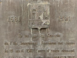
The union act between the three districts was signed on 21 April 1581 to create Martigues. Commemorative plaque.
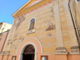
The Saint Louis church was rebuilt in 1675.
Its bell tower is surmounted by a stone spire whose sobriety clearly indicates the modesty of this church, in the district of Ferrières, the poorest district of Martigues in the 17th century.
Note attached to the entrance, the rustic portal with the broken pediment of the old chapel of the Pénitents Bleus.
Ferrières: With about 800 inhabitants, mainly fishermen and craftsmen, the district of Ferrières is the most modest (and least populated) of the three. On an east-west axis, the main street, also called rue Droite, crosses Ferrières from the Porte de Fos to the Etang de Berre. Open to the pond, Ferrières is defended, on the north side, by a wall, still visible today on Boulevard du 14 Juillet. The district has its church as well as two chapels. There is also an oven and an oil mill.
The island: The island occupies a central position between Jonquières and Ferrières, to which it is connected by bridges. It is the largest, most populated and most prosperous of the three districts. About 2,000 inhabitants live there, among whom the cadastre counts no less than 391 landowners, or 52% of the new municipality. Very dense, the habitat is distributed in a balanced way to the north and south of the rue Droite (today, rue de la République). At the end of the 16th century, its walls were in ruins, whereas, 200 years earlier, they made it the safest district. The island has two places: the Plan de la Tour and the Arénier, the current place Mirabeau. There are the richest houses belonging to bourgeois and merchants, as well as important public facilities, used by the other districts: a school and a tennis court.
Jonquières: The district of Jonquières then had a little over 1,000 inhabitants. It is separated from the island by two bridges, via another island, the Plan de Meyran, which no longer exists today. Set up between the 13th and 14th centuries, its plan is characterized by a regular grid on either side of the rue Droite, the current rue Lamartine. Directly in contact with the pond to the north and east, the district has walls on the land side, to the south and to the west, which have been altered several times. Jonquières has only one place, that of the Church, and two seigniorial ovens for all collective equipment.
April 21, 1581, Martigues becomes a commune.
July 4, 1580, Henri III, King of France, made Martigues a Principality. He wants to pacify this part of the kingdom, plagued by religious wars and princely struggles. The business is led on the spot by his representative, the duke Henri d'Angoulême, bastard brother of the king, governor of Provence, grand prior of the order of the Hospitallers of Saint-Jean of Jerusalem. Admiral of the Levant fleet, he also assigned himself the mission of restoring the fleet in the Mediterranean, which had been plagued by Spanish threats and claims.
In this regard, Martigues was of considerable strategic importance on the Provençal coast, thanks to its outer harbor and its fortress of Bouc which controls access to the lake. But with its three rival communities, Martigues offered the image of division: Jonquières depended on the Abbey of Montmajour, Ferrières on the Archbishop of Arles and the Island was under the authority of the Count of Provence.
It was therefore at the king's request that, on April 21, 1581, in the Saint-Louis de Ferrières church, the 18 representatives of each of the three communities approved their merger into a single city: Martigues.
General information
- Parking :
- Parking nearby
- Environments :
- In centre of town
- Town location
- Pedestrian area
- Period :
- 17th C
Accessibility
- Accessible to disabled visitors :
- Reception staff sensitized to the reception of people with disabilities
- Accessibility criteria for people with reduced mobility :
- Accessible for wheelchairs with assistance
Contact
Eglise Saint Louis d'Anjou
2 rue du colonel Denfert-Rochereau
Ferrières
13500
Martigues
Phone : +33 4 42 42 10 65
Prices
Free entry.

Destination
Eglise Saint-Louis d'Anjou
2 rue du colonel Denfert-Rochereau
Ferrières
13500
Martigues
GPS coordinates
Latitude : 43.408076
Longitude : 5.054737
Marseille Provence: Airport / Aerodrome 20 km
Martigues Lavéra station: Train station at 4 km
Martigues Lavéra station: Train station at 4 km