
Massifs de sainte Victoire et Concors
Mountain


Presentation
Located in the North-East of the department, the massifs of Concors and Sainte-Victoire form a large forest complex from the South of Sainte-Victoire to the Durance Valley in the North, from the Venelles depression in the West to the Rians valley in the East.
Situated to the far northeast of the Bouches-du Rhône, the Massif du Concors and Massif de la Sainte-Victoire form a large forest chain stretching from Sainte-Victoire mountain to the South, to Durance valley to the North, Venelles valley to the West and Rians valley to the East.
Le Concors comprises a generally west-southwest / east-northeast facing hill chain, spanning the Durance piedmont up to Vauvenargues valley to the North. Reaching a height of 781 m at the summit of Concors, these hills are carved with steep, globally North-South facing valleys.
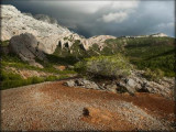
The West-East oriented Sainte-Victoire rises to an altitude of 1011m at Pic des Mouches and is characterised by highly contrasted ubac (North-facing) and adret (South-facing) slopes. It is bordered to the South by peripheral plateaux running successively from West to East: Plateau de Bibemus, Le Cengle and Plateau de Pallières, located on the fringe of the Var region, all at altitudes of less than 500 m.
The northern hills and Sainte-Victoire mountain are not accessible to traffic, contrary to the southern plateaux, which feature several public roads.
The roads crossing this vast geographical entity are globally laid out from East to West in the valleys and plains, with the exception of the D11 road which provides an internal junction between Jouques and Vauvenargues.
The prevailing wind in the massifs is a diverted Mistral, whose direction varies from 280 - 340°. Wind strength diminishes considerably from West to East. A southwesterly sea breeze blows just a few dozen days every day.
The Massif du Concors and Massif de la Sainte-Victoire are densely forested (73 %) with mature and high-quality trees, comprising 38 % Aleppo pines, and 36 % leafy varieties with predominant evergreen oak coppices. The remaining vegetation comprises sparser, more or less wooded garrigue.
The Massif du Concors and Massif de la Sainte-Victoire are part of the "Grand Site Sainte-Victoire", acclaimed for its historical, archaeological and natural riches and encompassing Sainte-Victoire mountain (Natura 2000 site). The Concors is currently pending Natura 2000 classification. This famous and emblematic geographical ensemble is also home to an exceptional natural, geological (Sainte-Victoire geological reserve) and biological heritage (Natura 2000 classification).
In terms of environmental protection, over 20 % of this territory is classified as an exceptional ecological heritage site, and it is home to over 200 species of remarkable flora and fauna.
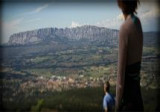
The internationally-famed Sainte-Victoire mountain and its vicinity are highly frequented, with over 900,000 visitors per year, while the more "confidential" Concors, situated to the North, is more generally frequented by locals.
Globally, these massifs are home to 240 km of footpaths and six Forest Welcome Sites (ZAPEF), mainly concentrated on the southern slopes of Sainte-Victoire.
The outskirts of the massifs, in particular to the West (around Aix-en-Provence, Venelles and Meyrargues) and northwest (adjacent to Peyrolles and Saint-Paul), are highly urbanized.
Le Concors comprises a generally west-southwest / east-northeast facing hill chain, spanning the Durance piedmont up to Vauvenargues valley to the North. Reaching a height of 781 m at the summit of Concors, these hills are carved with steep, globally North-South facing valleys.
The West-East oriented Sainte-Victoire rises to an altitude of 1011m at Pic des Mouches and is characterised by highly contrasted ubac (North-facing) and adret (South-facing) slopes. It is bordered to the South by peripheral plateaux running successively from West to East: Plateau de Bibemus, Le Cengle and Plateau de Pallières, located on the fringe of the Var region, all at altitudes of less than 500 m.
The northern hills and Sainte-Victoire mountain are not accessible to traffic, contrary to the southern plateaux, which feature several public roads.
The roads crossing this vast geographical entity are globally laid out from East to West in the valleys and plains, with the exception of the D11 road which provides an internal junction between Jouques and Vauvenargues.
The prevailing wind in the massifs is a diverted Mistral, whose direction varies from 280 - 340°. Wind strength diminishes considerably from West to East. A southwesterly sea breeze blows just a few dozen days every day.
The Massif du Concors and Massif de la Sainte-Victoire are densely forested (73 %) with mature and high-quality trees, comprising 38 % Aleppo pines, and 36 % leafy varieties with predominant evergreen oak coppices. The remaining vegetation comprises sparser, more or less wooded garrigue.
The Massif du Concors and Massif de la Sainte-Victoire are part of the "Grand Site Sainte-Victoire", acclaimed for its historical, archaeological and natural riches and encompassing Sainte-Victoire mountain (Natura 2000 site). The Concors is currently pending Natura 2000 classification. This famous and emblematic geographical ensemble is also home to an exceptional natural, geological (Sainte-Victoire geological reserve) and biological heritage (Natura 2000 classification).
In terms of environmental protection, over 20 % of this territory is classified as an exceptional ecological heritage site, and it is home to over 200 species of remarkable flora and fauna.
The internationally-famed Sainte-Victoire mountain and its vicinity are highly frequented, with over 900,000 visitors per year, while the more "confidential" Concors, situated to the North, is more generally frequented by locals.
Globally, these massifs are home to 240 km of footpaths and six Forest Welcome Sites (ZAPEF), mainly concentrated on the southern slopes of Sainte-Victoire.
The outskirts of the massifs, in particular to the West (around Aix-en-Provence, Venelles and Meyrargues) and northwest (adjacent to Peyrolles and Saint-Paul), are highly urbanized.
Practical information
- Visits :
- you can visit it
Contact
Massifs de sainte Victoire et Concors
13490
Jouques
Destination
Massifs de Sainte Victoire et Concors
13490
Jouques
GPS coordinates
Latitude : 43.6123
Longitude : 5.57783
We also suggest...
