
Le canal de Marseille
River


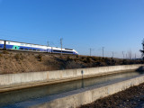
. Au premier plan, le canal EDF.")


Presentation
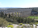
Concrete canal built from 1839 to 1854, 80 km long and composed of basins, and numerous technical works (including the Aqueduct of Roquefavour). It starts from Saint Estève Janson, and provides water to the communes up to Marseille.
The canal of Marseille collects at the level of Saint Estève Janson, a part of the waters diverted by the EDF canal. With a length of 80 km for its main branch (of which 17 km are underground) and 160 km for its derivations, its vocation is the supply of drinking water to the communes up to Marseille: Lambesc, La Barben, Coudoux, Ventabren, Aix, Cabriès, then Aubagne, Gémenos or Cassis...
It was built in the middle of the 19th century in about fifteen years under the direction of the engineer Franz Mayor de Montricher. Numerous works (500 in number) were built along its course, the most impressive of which is the Aqueduct of Roquefavour in Ventabren.
It was built in the middle of the 19th century in about fifteen years under the direction of the engineer Franz Mayor de Montricher. Numerous works (500 in number) were built along its course, the most impressive of which is the Aqueduct of Roquefavour in Ventabren.
Opening period (s)All year round.
Practical information
- Visits :
- you can visit it
Contact
Le canal de Marseille
13610
Saint-Estève-Janson
Destination
Le canal de Marseille
13610
Saint-Estève-Janson
GPS coordinates
Latitude : 43.716375
Longitude : 5.303242