
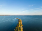
The Berre lagoon
Pond


Presentation
This lagoon covers 15,500 hectares, and its 75 km shoreline is quite charming.
Surrounded by low limestone hills, it receives fresh water from the Rivers Arc and Touloubre and the canal from the EDF hydroelectric power station. It is connected to the sea by the Caronte canal and Le Rove canal.
Surrounded by low limestone hills, it receives fresh water from the Rivers Arc and Touloubre and the canal from the EDF hydroelectric power station. It is connected to the sea by the Caronte canal and Le Rove canal.
The area has always been a place of human settlement, as shown by the archaeological digs of Saint-Blaise, Flavians Bridge, the mediaeval town of Miramas-le-Vieux and the 17th century town walls of Port-de-Bouc. From the end of the 19th century, the traditional economy based on wine, olives, peaches and salt mining was overturned by industrialization.
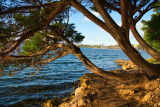
There is a clear distinction between the northern and southern parts of the area: the south and south-east have sacrificed a lot to industrialization, while the north and north-west have retained a more traditional character, with pinewoods and crops.
There is a clear distinction between the northern and southern parts of the area: the south and south-east have sacrificed a lot to industrialization, while the north and north-west have retained a more traditional character, with pinewoods and crops.
Practical information
- Visits :
- you can visit it
Destination
Etang De Berre
13130
Berre-l'Étang
GPS coordinates
Latitude : 43.463137
Longitude : 5.171127