
Rivière La Durance
River


Presentation
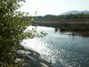
A great river, both alpine and Mediterranean, the Durance takes its source in the Hautes Alpes, at an altitude of 2300 m, at the foot of Mount Chenaillet, a fossil oceanic volcano 150 million years old, near the Montgenèvre pass near Italy.
With its 324 km, it is the most important river of Provence and the second largest tributary of the Rhone.
The Durance was formerly feared for its floods. Today, apart from the energy that the hydroelectric production gives, agriculture is the greatest beneficiary of these installations.
Divided into 3 parts (the Upper, Middle and Lower Durance), it irrigates the regional economy.
Its basin covers more than half of the Provence Alpes Côte d'Azur region, with nearly 14,200 km². The Durance valley traces a route from North to South which crosses four departments and plateaus, all of which are steeped in history. It is the true backbone of Provence: from the Alps to the Crau plain, the Durance crosses the current Provence-Alpes-Côte-d'Azur. The Durance provides 75% of the water needs of the PACA region.
In the 19th century, when the city of Marseille often had to face epidemics and droughts, it was decided to bring the water of the Durance to the city of Marseille, thanks to the construction of the Canal de Marseille, an important work which still functions today, and offers jewels such as the Aqueduct of Roquefavour!
In the past, the Durance was reputed to be impassable, because of its strong flow and its great width. It was even said: the mistral, the Parliament (of Aix-en-Provence) and the Durance are the three scourges of Provence! The Durance served as a border during the Roman period and then became, in the Middle Ages, the best means for transporting wood. But the Durance is always in flood, and in particular between 1843 and 1856, period during which the biggest devastations prevail, on the cultures but also on the houses. The idea of a dam was born at that time, but it was not realized until 1961, at Serre-Ponçon. This dam required 6 years of work as well as the destruction of several villages and hamlets, today fled under the water! The dam constitutes an immense reservoir for the irrigation of the Durance valley. It is to this day the second largest artificial lake in Europe!
Today, the Durance is much calmer and less wide, and does not constitute any more a threat for the neighbouring dwellings. It has become one of the most frequented gateways to winter sports. The most beautiful ski resorts of France are located there, notably Serre Chevalier, Montgenèvre... It is up to us, the people of Provence, not to forget that the Durance has been for centuries a great route of human transhumance with, among others, the Vaudois, Gavots and Radeliers...
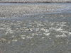
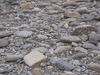
The regular flooding of the Durance maintains a diversity of natural habitats in perpetual movement: gravelly, sandy or silty islets, ponds, lônes, adoux, raised terraces... - These habitats host a fauna and a flora particularly adapted to this dynamic. On the margins, a riparian vegetation has developed, which has increased since the development of the river, even though it may have been significantly affected locally. Reed beds are developing in the former gravel pits of the major bed and the tails of the dams.
The Durance constitutes a fine example of a Mediterranean river system, presenting an imbrication of more or less humid natural environments linked to the dynamics of the watercourse. The variety of the ecological situations is translated by a great diversity of natural habitats: low vegetation of gravelly banks and deposits of silts, low woodlands, stretches of open water, dead arms directly associated with the bed of the river, as well as various forms of forests installed on the banks. Most of these habitats are reworked with each flood and thus present a great instability and originality.
The site presents a particular interest since it concentrates, in a reduced space, numerous natural habitats of community interest at the same time marked by the Mediterranean and mountain influences.
The Durance ensures an important functional role for the fauna and flora: function of corridor (movement of species, such as certain migratory fish, chiropterans, insects...), function of diversification (mixture of mountain and Mediterranean species) and function of refuge (relict natural environments allowing the survival of numerous species).
Concerning the fauna, the Durance presents a particular interest for the conservation :
- of various species of bats
- of the Apron du Rhône, a fish highly threatened with extinction
Species which have disappeared or whose presence remains rare: European otter, Lamprey of Planer.
The Durance was formerly feared for its floods. Today, apart from the energy that the hydroelectric production gives, agriculture is the greatest beneficiary of these installations.
Divided into 3 parts (the Upper, Middle and Lower Durance), it irrigates the regional economy.
Its basin covers more than half of the Provence Alpes Côte d'Azur region, with nearly 14,200 km². The Durance valley traces a route from North to South which crosses four departments and plateaus, all of which are steeped in history. It is the true backbone of Provence: from the Alps to the Crau plain, the Durance crosses the current Provence-Alpes-Côte-d'Azur. The Durance provides 75% of the water needs of the PACA region.
In the 19th century, when the city of Marseille often had to face epidemics and droughts, it was decided to bring the water of the Durance to the city of Marseille, thanks to the construction of the Canal de Marseille, an important work which still functions today, and offers jewels such as the Aqueduct of Roquefavour!
In the past, the Durance was reputed to be impassable, because of its strong flow and its great width. It was even said: the mistral, the Parliament (of Aix-en-Provence) and the Durance are the three scourges of Provence! The Durance served as a border during the Roman period and then became, in the Middle Ages, the best means for transporting wood. But the Durance is always in flood, and in particular between 1843 and 1856, period during which the biggest devastations prevail, on the cultures but also on the houses. The idea of a dam was born at that time, but it was not realized until 1961, at Serre-Ponçon. This dam required 6 years of work as well as the destruction of several villages and hamlets, today fled under the water! The dam constitutes an immense reservoir for the irrigation of the Durance valley. It is to this day the second largest artificial lake in Europe!
Today, the Durance is much calmer and less wide, and does not constitute any more a threat for the neighbouring dwellings. It has become one of the most frequented gateways to winter sports. The most beautiful ski resorts of France are located there, notably Serre Chevalier, Montgenèvre... It is up to us, the people of Provence, not to forget that the Durance has been for centuries a great route of human transhumance with, among others, the Vaudois, Gavots and Radeliers...
The regular flooding of the Durance maintains a diversity of natural habitats in perpetual movement: gravelly, sandy or silty islets, ponds, lônes, adoux, raised terraces... - These habitats host a fauna and a flora particularly adapted to this dynamic. On the margins, a riparian vegetation has developed, which has increased since the development of the river, even though it may have been significantly affected locally. Reed beds are developing in the former gravel pits of the major bed and the tails of the dams.
The Durance constitutes a fine example of a Mediterranean river system, presenting an imbrication of more or less humid natural environments linked to the dynamics of the watercourse. The variety of the ecological situations is translated by a great diversity of natural habitats: low vegetation of gravelly banks and deposits of silts, low woodlands, stretches of open water, dead arms directly associated with the bed of the river, as well as various forms of forests installed on the banks. Most of these habitats are reworked with each flood and thus present a great instability and originality.
The site presents a particular interest since it concentrates, in a reduced space, numerous natural habitats of community interest at the same time marked by the Mediterranean and mountain influences.
The Durance ensures an important functional role for the fauna and flora: function of corridor (movement of species, such as certain migratory fish, chiropterans, insects...), function of diversification (mixture of mountain and Mediterranean species) and function of refuge (relict natural environments allowing the survival of numerous species).
Concerning the fauna, the Durance presents a particular interest for the conservation :
- of various species of bats
- of the Apron du Rhône, a fish highly threatened with extinction
Species which have disappeared or whose presence remains rare: European otter, Lamprey of Planer.
Opening period (s)From 01/01 to 31/12 daily.
Practical information
- Services :
- Pets welcome
- classifications :
- classifications
Destination
Rivière La Durance
04100
Manosque
GPS coordinates
Latitude : 43.803967
Longitude : 5.823968