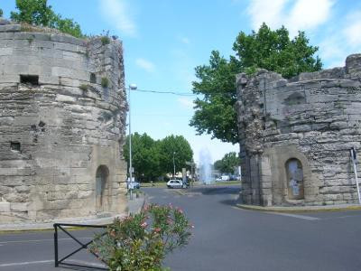
Door of the cavalry
Historic site and monumentPresentation
Date: 1588
Period: Renaissance
Type : Fortified military architecture
Status : Property of the City of Arles, classified as a historic monument (1928)
Period: Renaissance
Type : Fortified military architecture
Status : Property of the City of Arles, classified as a historic monument (1928)
The Porte de la Cavalerie (Cavalry Gate), with its two round towers, stands at the northern entrance to the old town center. Its name recalls the settlement of the Knights of the Temple in this district in the Middle Ages. As early as the 13th century, after the birth of new districts such as Bourg-Neuf (today's Cavalerie district), the perimeter of the town - which remained virtually unchanged until the 19th century - was entirely surrounded by ramparts. Beyond the gate began the fields and pastures now occupied by Place Lamartine and the railway station district (19th century), and later by the northern districts of the agglomeration. Rebuilt in the 16th century, the building was completed in the 18th century, but was partially destroyed during the French Revolution and again in 1877. All that remains of the building today are two round towers with bossing and fragments of the eastern and northern walls, the gate itself having been demolished.
It was built from large stones taken from the towers of the Porte de Laure, and featured a drawbridge spanning the roubine du roy (a drainage canal used to drain the marshland). The roubine used to run in the open along the rampart before emptying into the Rhône, and was covered over in 1901. In the 18th century, the gate was completed with a half-moon defense (a semi-circular space in front of the gate).
It was built from large stones taken from the towers of the Porte de Laure, and featured a drawbridge spanning the roubine du roy (a drainage canal used to drain the marshland). The roubine used to run in the open along the rampart before emptying into the Rhône, and was covered over in 1901. In the 18th century, the gate was completed with a half-moon defense (a semi-circular space in front of the gate).
General information
- Style :
- Renaissance
- Park :
- Camargue Regional Nature Park
Services, Tours, Activities and entertainment
- Historical patrimony :
- Historic patrimony
- Door

Destination
Porte de la Cavalerie
13200
Arles
GPS coordinates
Latitude : 43.681327
Longitude : 4.631402


