
Departmental Park of Roques Hautes
Uplands


Presentation
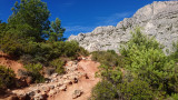
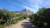
Below the Sainte-Victoire Mountain, the Parc Départemental de Roques Hautes straddles the municipalities of Saint-Antonin-sur-Bayon, Beaurecueil, Le Tholonet and Aix-en-Provence.
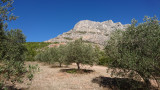
With a surface area of 700 hectares, you can enjoy a panorama of rugged terrain and ochre colors (red, orange, yellow) and rock.
Paul Cézanne, easel on the shoulder, then Emile Zola immortalized it many times.
Roques-Hautes is also ruins, a deposit of dinosaur eggs classified as a nature reserve (forbidden to the public) and a marble quarry from the breccia of Tholonet.
It is also 25 hectares of tree plantations - almond trees, fig trees, truffle oaks, olive trees producing an AOC (Appellation d'Origine Contrôlée) oil - which attest to the strong involvement of the Department, which bought the site between 1973 and 1988, in the preservation and rehabilitation of the site.
Management of the natural area : Domaine du Conseil Général
Classified site
Accessible for disabled
Practical information
- Visits :
- you can visit it
- Parking :
- Parking nearby
Contact
Departmental Park of Roques Hautes
13090
Aix-en-Provence
Destination
Parc Départemental de Roques Hautes
13090
Aix-en-Provence
GPS coordinates
Latitude : 43.5315
Longitude : 5.4998