
Réserve du Cap Couronne (réserve Richard Fouque)


Presentation
Following the evolution of the environment linked to the management and protection of the Carry-le-Rouet reserve, the representatives of professional fishermen from Martigues wished to carry out a development project for the seabed in front of Cap-Couronne. .
This project took shape in 1996, with the creation of one of the largest fully protected marine areas in the Mediterranean.
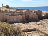
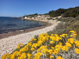
This 210 ha area begins about 50 meters from the coast, between Cap-Couronne and Pointe Noire. Two spar buoys mark these two coastal ends. It stretches out to sea about 1 mile to a depth of 50 meters.
The seabed consists of corraligenous, sand, rock and Posidonia meadows. The reserve is delimited to the south by 2 light buoys. Three spar buoys are placed in an intermediate position, each on one of the east, west and north sides. The buoys are all surmounted by a Cross of Saint Andrew.
For the protection and repopulation of the marine environment, the following activities are prohibited throughout the year:
- Professional fishing,
- Underwater fishing,
- Angling,
- Scuba diving,
- Mooring of boats.
• Ministerial decree of 01/07/2014
• Decree of the Maritime Prefecture 16/12/2014
Practical information
- Visits :
- you can visit it
Contact
Réserve du Cap Couronne (réserve Richard Fouque)
13500
Martigues
Destination
Réserve du Cap Couronne (réserve Richard Fouque)
13500
Martigues
GPS coordinates
Latitude : 43.327425
Longitude : 5.044613
We also suggest...
