
The Blue Coast and the Estaque Hills


Presentation
The Cote Bleue has a limestone and indented coastline that stretches over some thirty kilometres between Martigues and Marseille.
The Côte Bleue (Blue Coast) is a jagged limestone coastline that stretches for 30 kilometres between Martigues and Marseille. It is a succession of calanques (coves), little creeks and beaches nestling against the Estaque Hills
One side of this chain encloses the Bay of Marseille on the north-west and, at the same time, its other side protects the basin of Berre Lagoon. It is a limestone arc of wild landscape, cut into by narrow winding vales at medium altitudes (180 - 280 m).
The hills drop sharply into the sea along most of the coast; sometimes fishermens hamlets and weekend cabins cling to the steep crags. In the western part, the chain softens into plateaux and there are fine sandy beaches.
A regional marine park was created in 1983 on the initiative of four local councils. It includes a 70 hectares conservation area off the coast from Sausset, and a peripheral area of 3,000 hectares that includes the entire coastline of the Blue Coast.
There are splendid views from the coastal railway, which was built at the start of the century with several viaducts and tunnels.
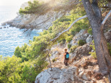
The best way to explore this coastline by car is to take the roads that go around little pleasure ports, skim the cliffs and wind through the rocky vales and the pinewoods. There are many suitable places for taking casual walks or longer hikes. A footpath called the "Customs officers footpath" is being built along the coastline.
There is an abrupt descent into the calanque of La Redonne and then acrobatic paths lead to the calanques of Figuières and Méjean. A little further on are Madrague-de-Gignac and Niolon, a small village hanging on the rocky slopes at the end of the calanque of the same name, flanked by a 19th century fort with its cannons, where there is a very active diving centre.
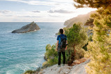
Bare and windswept Cap Couronne has a magnificent panorama of the coast and the Bay of Marseille.
One side of this chain encloses the Bay of Marseille on the north-west and, at the same time, its other side protects the basin of Berre Lagoon. It is a limestone arc of wild landscape, cut into by narrow winding vales at medium altitudes (180 - 280 m).
The hills drop sharply into the sea along most of the coast; sometimes fishermens hamlets and weekend cabins cling to the steep crags. In the western part, the chain softens into plateaux and there are fine sandy beaches.
A regional marine park was created in 1983 on the initiative of four local councils. It includes a 70 hectares conservation area off the coast from Sausset, and a peripheral area of 3,000 hectares that includes the entire coastline of the Blue Coast.
There are splendid views from the coastal railway, which was built at the start of the century with several viaducts and tunnels.
The best way to explore this coastline by car is to take the roads that go around little pleasure ports, skim the cliffs and wind through the rocky vales and the pinewoods. There are many suitable places for taking casual walks or longer hikes. A footpath called the "Customs officers footpath" is being built along the coastline.
There is an abrupt descent into the calanque of La Redonne and then acrobatic paths lead to the calanques of Figuières and Méjean. A little further on are Madrague-de-Gignac and Niolon, a small village hanging on the rocky slopes at the end of the calanque of the same name, flanked by a 19th century fort with its cannons, where there is a very active diving centre.
Bare and windswept Cap Couronne has a magnificent panorama of the coast and the Bay of Marseille.
Opening period (s)All year round.
Practical information
- Visits :
- you can visit it
Contact
The Blue Coast and the Estaque Hills
13620
Carry-le-Rouet
Phone : +33 4 42 20 03 83
Destination
La Côte Bleue - Massif de la Nerthe
13620
Carry-le-Rouet
GPS coordinates
Latitude : 43.328799
Longitude : 5.130787
Between 1 June and 30 September, access to the forests is regulated by prefectoral decree and may be regulated by municipal decree, for your safety and the preservation of sensitive sites. Before you decide to go for a walk, call 0811 20 13 13. Every day, you will be able to find out whether the site where you wish to go for a walk is open all day long, open only in the morning, or completely closed. Depending on the weather conditions, the level of danger "forest fire" (green, yellow, orange, red) is known at the latest at 6pm for the next day.
We also suggest...
- Parc marin de la Côte Bleue
