
Chaîne des Côtes
Mountain


Presentation
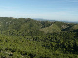
The massifs of the Roques, the Chaîne des Côtes and the Trévaresse form a large wooded area, located in the north of the department.
This massif is delimited to the North by the Durance, to the South by the Quatre Termes massif, the Aix plain, to the West by the A7 freeway and to the East by the A51 freeway.
The massif des Roques whose altitude varies from 394 m at Vernègues to 83 m in the plains, is a massif with varied reliefs, very uneven with steep slopes, deep valleys and interior plateaus. The general orientation of the relief is West/South-West / East/North-East, following the limestone cliffs, the valleys being globally oriented North-South.This part is crossed by the RD16 and 22, as well as by the TGV Mediterranean line.
The Côtes range, forms a more compact massif with limestone entablatures and cliffs, facing the Luberon beyond the Durance. This massif culminates at 482 m and is erected like a chain stretched in a generally East-West direction, between the Durance plain and the Lambesc plain. It is characterized by a particularly uneven relief, especially on the north side, giving it a quasi-mountainous characteristic and allowing its crossing only via the D67 and the plateau of Malivert. It is prolonged by the sub-massifs of Saint-Estève and La Quille, which form a succession of small, looser hills, with gentle shapes that start from the Saint-Christophe basin and end up on the Trévaresse plateau. Culminating is at 482 m, this sub-assembly is oriented North-West / South-East, with valleys regularly cutting it in a North-East / South-West direction. It is only crossed by the D66, linking Saint-Estève Janson to Rognes.
The Trévaresse plateau stands as a tabular barrier oriented East-West, to the North of the Aix plain. This plateau is crossed by numerous public roads with a general North-South orientation: D13, D14, D543 and D18. It culminates at 502 m south of Cabannes, and is clearly separated into a northern and a southern slope, both with regular slopes.
Located in the climatological zone of coastal Provence ... the massifs of the Roques, the Chaîne des Côtes and the Trévaresse are marked by rather mild average annual temperatures (13 ° C) and rather low average rainfall (600 to 700 mm/year). The dominant wind is a deviated mistral ...
Belonging to the small natural region of the Coteaux de Basse Durance, the massifs of the Roques, the Chaîne des Côtes and the Trévaresse are, with those of the Concors and the Sainte-Victoire, the most forested of the department.
The very wooded aspect of this massif constitutes a major element of the living environment for most of the villages having as a background a view on these very forested hills, of wild aspect. For all that, these massifs do not include strong legal servitudes. It can be noted that all of the northern hills are part of the vast ZICO "plateau de l'Arbois, garrigues de Lançon and Chaîne des Côtes" linked to the quality and naturalness of the environments offered for birds on the Durance balcony (Bonelli's Eagle, Egyptian Vulture, Great Horned Owl, Montagu's Harrier...) On the Commune of La Barben, the Voluntary Nature Reserve of the Saint-Pons property (285 ha) exists since 1991. These three massifs also include several ZNIEFF in relation to valleys, open ridge areas and particular geological formations.
Practical information
- Visits :
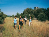
- you can visit it
Contact
Chaîne des Côtes
13090
Aix-en-Provence
Destination
Chaîne des Côtes
13090
Aix-en-Provence
GPS coordinates
Latitude : 43.684114
Longitude : 5.26665